Farming is one of the promising applications of UAVs mainly because its a relatively safe environment away from people and built up locations (which are one of the main safety/privacy concerns)
A recent publication in the open access journal PLOS describes a method for detecting weeds from UAV images early on in the season.
The use of remote imagery captured by unmanned aerial vehicles (UAV) has tremendous potential for designing detailed site-specific weed control treatments in early post-emergence, which have not possible previously with conventional airborne or satellite images. A robust and entirely automatic object-based image analysis (OBIA) procedure was developed on a series of UAV images using a six-band multispectral camera (visible and near-infrared range) with the ultimate objective of generating a weed map in an experimental maize field in Spain. The OBIA procedure combines several contextual, hierarchical and object-based features and consists of three consecutive phases: 1) classification of crop rows by application of a dynamic and auto-adaptive classification approach, 2) discrimination of crops and weeds on the basis of their relative positions with reference to the crop rows, and 3) generation of a weed infestation map in a grid structure. The estimation of weed coverage from the image analysis yielded satisfactory results. The relationship of estimated versus observed weed densities had a coefficient of determination of r2=0.89 and a root mean square error of 0.02. A map of three categories of weed coverage was produced with 86% of overall accuracy. In the experimental field, the area free of weeds was 23%, and the area with low weed coverage (<5% weeds) was 47%, which indicated a high potential for reducing herbicide application or other weed operations. The OBIA procedure computes multiple data and statistics derived from the classification outputs, which permits calculation of herbicide requirements and estimation of the overall cost of weed management operations in advance.
You can find the paper here
Weed Mapping in Early-Season Maize Fields Using Object-Based Analysis of Unmanned Aerial Vehicle (UAV) Images
As a follow on I have also found an earlier paper by the same authors that describe the setup and procedures for obtaining the images. The paper above is all about the analysis of the UAV images, and the one below is about the configuration and setup.

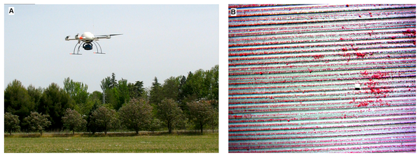
A new aerial platform has risen recently for image acquisition, the Unmanned Aerial Vehicle (UAV). This article describes the technical specifications and configuration of a UAV used to capture remote images for early season site- specific weed management (ESSWM). Image spatial and spectral properties required for weed seedling discrimination were also evaluated. Two different sensors, a still visible camera and a six-band multispectral camera, and three flight altitudes (30, 60 and 100 m) were tested over a naturally infested sunflower field. The main phases of the UAV workflow were the following: 1) mission planning, 2) UAV flight and image acquisition, and 3) image pre-processing. Three different aspects were needed to plan the route: flight area, camera specifications and UAV tasks. The pre-processing phase included the correct alignment of the six bands of the multispectral imagery and the orthorectification and mosaicking of the individual images captured in each flight. The image pixel size, area covered by each image and flight timing were very sensitive to flight altitude. At a lower altitude, the UAV captured images of finer spatial resolution, although the number of images needed to cover the whole field may be a limiting factor due to the energy required for a greater flight length and computational requirements for the further mosaicking process. Spectral differences between weeds, crop and bare soil were significant in the vegetation indices studied (Excess Green Index, Normalised Green-Red Difference Index and Normalised Difference Vegetation Index), mainly at a 30 m altitude. However, greater spectral separability was obtained between vegetation and bare soil with the index NDVI. These results suggest that an agreement among spectral and spatial resolutions is needed to optimise the flight mission according to every agronomical objective as affected by the size of the smaller object to be discriminated (weed plants or weed patches).
You can find the paper here
Configuration and Specifications of an Unmanned Aerial Vehicle (UAV) for Early Site Specific Weed Management
